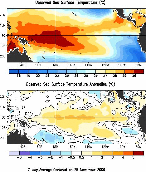
The most recent measurements of sea surface temperatures for the last week of November from NOAA is shown here (notice the band of above normal temperatures at the equator stretching form the dateline to Peru):

Reference: El Niño/La Niña Home (Climate Prediction Center, NOAA)
A recent article Trends in Twentieth-Century U.S. Extreme Snowfall Seasons (Journal of Climate, Dec, 2009), looks at the relationship between El Nino and extreme winter snowfall across the USA over the last century.
Key Quotes:
"In almost all regions of the United States, temperature during November–March is more highly correlated than precipitation to the occurrence of extreme snowfall years"
" El Niño events are strongly associated with an increase in low-extreme snowfall years over the United States as a whole, and in the northwest, northeast, and central regions. "
Going out on a limb, one might expect to see warmer conditions than normal across North America this coming winter, along with extremely low snowfall in locations where the temperature anomalies are greatest- and as a result, poorer air quality can be expected in the same locations.
Let's check back next spring and see how it turned out.
Meanwhile here is the latest outlook from Environment Canada:
Forecast predicts less snow in Canada this year (CTV news and video)
Related articles by Zemanta
- New Methodology Improves Winter Climate Forecasting (usnews.com)
- El Nino weakening as hurricane season nears (seattletimes.nwsource.com)
- La Nina likely to develop in coming months: UN weather body (news.yahoo.com)
- Converging Weather Patterns Caused Last Winter's Huge Snows (usnews.com)
- La Nina developing, could mean more hurricanes (seattletimes.nwsource.com)
- Why is there so much more rain during el nino years? (greenanswers.com)

No comments:
Post a Comment