Wednesday, August 31, 2011

The Greenest American Cities

Top 10 Cities for Green Living (Scientific American, Aug. 16, 2011)

A rating of US cities by how well they perform when it comes to living green is the focus of today’s review. The two top cities under each category are shown below. Overall, New York City scored highest, winning the top spot in 3 of 5 categories: thinking, transportation and walkable.


Key Quotes:

“we feature lists that rank cities based on their green living opportunities, and then add up each city's rankings to find the best overall green living cities”

“Greenest Thinking - New York City, Las Vegas

Most Energy-Efficient BuildingsLos Angeles, Washington, D.C.

Best Public Transportation Systems- Denver-Aurora, Colo, New York City-Newark, N.J.

Most Bikeable – Minneapolis, Portland, Ore.

Most Walkable – New York City, San Francisco

==================================

Top 10 Overall Green Living Performances- New York City, San Francisco”
Enhanced by Zemanta

Tuesday, August 30, 2011

Peformance Prices for Parking

Progress in immobility - How optimization of stationary traffic can improve traffic flow (8 page pdf, Donald Shoup, ITS magazine- The Magazine for Intelligent Traffic Systems I 2/2011, Siemens, July 2011)

The patron saint of parking, Donald Shop, is the focus of today’s review. He points out the many issues caused by free parking and the need to do three things to create more mobility: “Charging performance prices for on-street parking, spending the revenue for local public services, and removing off-street parking requirements”


Key Quotes:

“Statistics reveal that cars and other motorized vehicles are on the move for about an hour a day on average – the other 23 hours are spent as “immobiles” in garages and other parking facilities”

“Paying for parking is like going to a prostitute,..Why should I pay when, if I apply myself, maybe I can get it for free?” (George Costanza, Seinfeld)

“Where curb parking is underpriced and overcrowded, a surprisingly large share of traffic may be cruising in search of a place to park…30 percent of the cars in congested traffic on city streets were cruising for parking”

“the average time to find a curb space on 15 blocks in the Upper West Side of Manhattan was 3.1 minutes and the average cruising distance was 0.6 kilometers.. cruising for underpriced park ing in this small area alone creates about 590,000 excess vehicle kilometers of travel and 295 tons of CO2 per year”

“some cities have begun to adjust their curb parking prices by location and time of day to produce an 85 percent occupancy rate for curb parking, which corresponds to one vacant space on a typical block with eight curb spaces”

“to convince people to charge for on-street parking ..dedicate the resulting revenue to paying for civic improvements in the neighborhood, such as repairing sidewalks, planting street trees, and putting utility wires underground”

“parking requirements force-feed the city with parking spaces, and removing a parking requirement simply stops the force-feeding. Ceasing to require off-street parking gives businesses the freedom to provide as much or as little parking as they like”

“Charging performance prices for on-street parking, spending the revenue for local public services, and removing off-street parking requirements will achieve the goals of almost all interest groups”
Enhanced by Zemanta

Monday, August 29, 2011

On-Street Parking

The importance of on-street parking (Steve Mouzon, New Urban Network, Aug. 10, 2011

Today’s focus is on the need for on-street parking and why the alternatives are unsafe, bad for business and generally bad for the urban environment.


Key Quotes:

Why on-street parking is needed:

“*Commercial parking lots

-if they are built in front of a building..nobody will ever walk on the sidewalk that runs between the parking lot and the street..beside the building.. snaggletooth streetscape..If everyone parks in back, then it seems logical to the building owner to put the front door in the back

*Residential parking

-double-wide driveways are big heat sinks with lots of stormwater runoff.

*Parking decks

-next to a sidewalk creates a terrible pedestrian environment.. Parking decks are broadly perceived as being scary places.. Bore the pedestrians, and they won't walk there. Build ugly buildings, and they'll abandon your sidewalk as well

*Liner buildings

-It is possible to fix parking decks by building what is known as a "liner building" between them and every adjacent sidewalk. A liner building is a thin building that "lines" the parking deck's outer edges

*The pedestrian shield

-One major source of fear is the possibility that a car might run off the street and hit you. On-street parking alleviates this fear

*Thriving retail

-every on-street parking space in a thriving retail district is worth $250,000 in sales to the nearby merchants on that street”
Enhanced by Zemanta

Friday, August 26, 2011

Gridlock – real or imaginary?

Traffic Gridlock: The Real Deal or a Pile of Nonsense? (26 page pdf, Barry Wellar, Jul. 28, 2011)

Also discussed here: Transportation: Inspiring a Sustainability Action Agenda (39 page pdf slideshow, May 14, 2011)

The focus today is on an analysis by a leading Ottawa expert on mobility, Prof. Barry Wellar. He sees the use of the term “gridlock” as a dichotomy between “research-based, and deserve to be treated as the real deal” or “not research-based, and deserve to be dismissed as a pile of nonsense”. The answer is left to the reader of his paper to answer. That said, the causes of gridlock and the impacts it might have on mobility in general and the environment in particular are worth examination.


(26 min YuTube video, May 14, 2011)


Key Quotes:

"… Besides, increased traffic is a natural outcome of the city's intensification goals."

“gridlock..used as a general purpose term to cover all manner of volume-related, capacity-related, and other kinds of problems associated with traffic flow interruptions, delays, diversions”

“if major corrective steps are not taken, entire cities will be going to transportation hell in a handcart on a daily basis because private motor vehicles – cars, SUVs, pick-ups, minivans, tractor trailers, etc. – will be in the grip of paralysing gridlock”

“the claims, pronouncements, exhortations, promises, profferings, threats, calls for attention, warnings, etc., about traffic gridlock lack methodological underpinnings, and in general appear to be at best the products of what has been described as anatomical sourcing”

Questions to be addressed:
  1. “What is the meaning of traffic gridlock?
  2. How is traffic gridlock defined?
  3. How is traffic gridlock measured?
  4. What is the process whereby traffic gridlock occurs?
  5. What is the established process whereby traffic gridlock is mitigated, resolved, or dissolved as the case may be?
  6. What are the full environmental, economic, financial, social, energy, and multi-modal transportation system benefits and costs of solving either chronic or temporary manifestations of so-called traffic gridlock?
  7. How do you methodologically measure the full environmental, economic, financial, social, energy, and multi-modal transportation system benefits and costs of solving either chronic or temporary manifestations of so-called traffic gridlock?”
Enhanced by Zemanta

Thursday, August 25, 2011

Traffic Air and Sound Pollution Impacts on Blood Pressure and Hypertension

Long-Term Urban Particulate Air Pollution, Traffic Noise and Arterial Blood Pressure (30 page pdf, Kateryna Fuks, Susanne Moebus, Sabine Hertel, Anja Viehmann, Michael Nonnemacher, Nico Dragano, Stefan Möhlenkamp, Hermann Jakobs, Christoph Kessler, Raimund Erbel, Barbara Hoffmann, |Environmental Health Perspectives, Aug. 9, 2011)

The focus today is on research into the impacts of long term exposure to emissions and noise from heavy traffic (greater than 22,000 vehicles/day) on blood pressure. The results point to a link even when the increase in PM concentration is small, because even a small increase over the long term has large impacts in population health terms.


Key Quotes:

“Urban PM air pollution is determined by multiple sources, including regionally transported PM,local industrial sources, home heating, and traffic”

“we investigated the cross-sectional association of long-term urban background particulate matter with arterial BP and hypertension in a population-based sample, taking longterm traffic noise and short-term variations of air pollution into account.”

“Residential proximity ≤50 m to high heavy-duty traffic and long-term road traffic noise >65 dB were associated with a somewhat higher prevalence of hypertension”

“long-term PM exposure may promote atherosclerosis with air pollution-induced increases in BP being one possible biologic pathway”

High BP is the most important determinant of cardiovascular mortality and even small changes on the population level can lead to a high burden of attributable disease”

“An exposure contrast of only few Lg/m3 PM2.5 in the urban background concentration may therefore lead to a shift in the population distribution of BP, similar in effect size to the dietary salt reductions”

“We consider these findings to be indicative of traffic-related effects on a small spatial scale, independent of and in addition to the effects of urban background air pollution”
Enhanced by Zemanta

Wednesday, August 24, 2011

Investing in Toll Roads Internationally

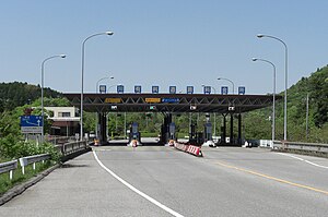
kamogawa toll roadImage via WikipediaFor Whom the Road Tolls: Reviewing Listed Toll Roads, Bridges and Tunnels (Seeking Alpha, May 3,2011)

Also discussed here: Publicly listed toll roads outside the USA (Road Pricing, Aug. 5, 2011)

And here: The Dow Jones Brookfield Toll Roads Infrastructure Index (3 page pdf, Dow Jones)

Today’s review article contains an investment analysis of 23 toll roads in 8 countries which differ significantly both in national financial policies and in the amounts invested and the returns and dividends. While Italy has the largest market capitalization for one toll road (Atlantia SPA), China’s roads offer the most attractive prospects with equity ratios as high as 70%.


Key Quotes:

“Nearly three thousand years ago, travelers had to pay a toll for using the Susa–Babylon highway under the regime of Ashurbanipal, who reigned in the seventh century BC. The business of toll collection has survived through the ages”

“there is a whole world of privately owned commercial, investment grade road assets, that are tolled, with publicly listed companies”

“Private toll roads were also introduced in America at the end of the 18th century, after private toll bridges were found to be extremely profitable businesses”

“The article summarises the state of 23 toll road companies that are publicly listed globally., 8 are Chinese, 4 in Italy, 3 in Australia, 3 in France, 2 in Brazil, 1 in Argentina, 1 in Portugal and 1 in Thailand”

“the Asian toll road operators offer the most attractive valuations, while some operators in Europe are also worth considering. Asian toll roads have the benefit of better economic prospects, more room for future growth in traffic, and a better balance sheet structure. They also currently offer higher dividend yields”

“Toll roads are local operations that have a fixed location, and their performance is linked to the local economy. Key drivers are, for example, the mobility of the population (number of cars), trade volumes between the node points of the highways, and the population of cities joined by them”

“China has the largest number of listed toll roads, and the eight I have listed have a total market capitalization of nearly $18bn. the Chinese toll roads have rather solid balance sheets. Their equity ratios range from 40% to 70%.”

“Existing toll roads might be sold, but highways that are now free to use may also become subject to tolls to replenish state coffers. For example, Germany is considering a toll for private cars (not just trucks) on its highways… Austria and Switzerland already charge tolls for their expressways (and some tunnels)”
Enhanced by Zemanta

Tuesday, August 23, 2011

Mid-Town Freeways, Sprawl and Quality of Life

A Distant Mirror: 40 Years of Urbanism in Vancouver (Nicholas Kevlahan, Raise the Hammer, Aug. 2, 2011)

Vancouver is the only major city on the continent that does NOT have a freeway through its centre. Result? It has developed into an urban planner’s dream with high population density and a quality of life that is the envy of many in leading cities around the world. Today’s review article examines the development of Vancouver over the last three decades and compares it to a comparably sized city, Hamilton, located west of Toronto which itself has sprawled in all directions thanks to its own freeway bisector, the 401.

The road not taken


Key Quotes:

“Vancouver's population density is almost twice that of Hamilton (and the density of the downtown is much greater: 35 000/km^2 for the West End)..there is one direction that is open to 'sprawl' development: to the south in Hamilton, and to the east along the Fraser Valley in Vancouver”

“Hamilton's economy was historically based on heavy manufacturing; the city has lost most of its large employers in the past three decades.. However, Vancouver has thrived with essentially no manufacturing (what little there was centred on False Creek and was essentially all gone by the 1970s)”

“in the early 1970s Vancouver made a fundamental choice that was to determine its future development. Vancouver refused to build a freeway system through the downtown core….the freeway would have been built in a massive 'ditch' below grade level, and its construction would have involved the wholesale demolition of (mostly poorer) neighbourhoods”

“The Vancouver model relies on a planning department that is largely independent of Council influence, and on the entire city staff (including the traffic department) being onside. This is contrary to the case in Hamilton where the progressive ideas of the planning department are often ignored or opposed by council or vetoed by the traffic department.. In addition, residents and developers tend to oppose any and all city planning decisions by appealing to the Ontario Municipal Board (OMB)”

“the Vancouver model:
  • Priority of the planning department within city administration: decisions are not overturned by other departments (emergency services, traffic).
  • Independence from Council interference on operational decisions (council decides the priorities and strategy, planning staff implements).
  • An interventionist and prescriptive approach to planning.
  • Built-form control and mandatory mixed use.
  • Prioritizing high density residential over commercial and office space downtown.
  • Prioritizing pedestrians above all other transportation modes, with through traffic as the lowest priority.
  • Flexible zoning allowing developers to gain increased height or density by providing public amenities (e.g. park space, view corridors or social housing)”
“Real Estate prices in Vancouver are extremely high: the average price throughout the GVRD is about $800 000 and the median price is about $600 000 ..Vancouver also suffers from pockets of extreme poverty, associated with drug use and criminality”
Enhanced by Zemanta

Monday, August 22, 2011

Health Impacts of Future Heat Waves as a result of Climate Change

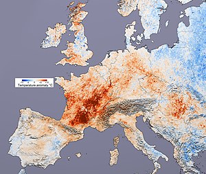
Temperature difference in Europe from the aver...Image via WikipediaProjecting Future Heat-related Mortality under Climate Change Scenarios: A Systematic Review (43 page pdf, Cunrui Huang, Adrian Gerard Barnett, Xiaoming Wang, Pavla Vaneckova, Gerard FitzGerald, Shilu Tong, |Environmental Health Perspectives, Aug. 4, 2011)

The focus of today’s review article is on the heat-related deaths likely under climate change scenarios that extend out 50 years. A literature search revealed that heat waves are the single largest cause of deaths of any severe weather and women particularly elderly women tend to suffer the most. Acclimatization to warmer temperatures is an important factor to avoid exaggerating the mortality impact. Air pollution will add to the impact from heat waves.

Key Quotes:

“heat waves are the biggest cause of weather-related fatalities in many cities, responsible for more deaths annually than any other form of extreme weather”

“People with cardiovascular or respiratory disease, diabetes, chronic mental disorders or other pre-existing medical conditions are at greater risk from heat exposure”

“The heat threshold is the temperature at which the harmful effect of heat begins to occur, and the heat slope measures the size of this effect”

“[in 44 USA cities] increases in heat-related mortality would range from 70% to over 100% in 2050, relative to the baseline 1964–1991 summer mortality”

“[in 3 Canadian cities] a significant increase in temperature related mortality in summer that was not offset by a significant but smaller estimated decrease in fall and winter mortality.

“In Lisbon, acclimatization could reduce heat-related deaths on average by 15% in the 2020s and 40% in the 2050s, relative to projections assuming no acclimatization”

“the effects of heat on mortality appear sometimes to be greater in women, especially elderly women”

“Air pollution is expected to increase in urban areas due to climate change, so the joint exposure of urban populations to high temperatures and air pollutants will increase in the future “
Enhanced by Zemanta

Friday, August 19, 2011

Risk Assessment and Air Pollution Epidemiology

Improving the Linkages between Air Pollution Epidemiology and Quantitative Risk Assessment (23 page pdf, Fann N, Bell ML, Walker K, Hubbell B, Environmental Health Perspectives, Aug. 4, 2011)

Today’s focus is on the link between the assessment of health risk on the one hand and the analysis of causes and effect of health impacts through epidemiology- and how one can complement the other. The review article considers a number of aspects: estimated effects, air quality, population and health data.


Key Quotes:

“The extent to which risk assessors can properly specify a quantitative risk assessment and characterize key sources of uncertainty depends in part on the availability, and clarity, of data and assumptions in the epidemiological studies”

“the role of air pollution epidemiology in supporting quantitative risk assessments—principally by providing the risk coefficients that relate air quality changes to the probability of a variety of adverse health outcomes, including premature death, hospital visits and acute respiratory symptoms among many others”

-policy questions:
  • “the total public health burden associated with exposure to air quality levels above some background level in terms of the number of excess cases of premature death or illness?”
  • “the impact on human health of incremental changes in air quality due to a proposed policy?”
Key attributes of epidemiological studies relevant to risk assessment:
  • Effect estimates - the U.S. EPA recently evaluated the long-term PM mortality literature to consider the empirical basis for a threshold in the concentration-response relationship. EPA found useful the graphics depicting the concentration-response curve and 95th percentile confidence interval over the range of the observed data
  • Air Quality - Risk assessments rarely have the opportunity to rely on risk coefficients from epidemiological studies in which the temporal and spatial variability in air quality is fully consistent with that of the policy scenarios being analyzed.
  • Population - risk assessments tend to estimate the incidence of adverse health outcomes among a population whose attributes are sometimes very different from the study population in ways that may alter the outcome of the risk assessment.
  • Health Data - consider which endpoints to quantify, how to match key characteristics of the endpoints across populations, and how and whether to pool evidence across studies.
Enhanced by Zemanta

Thursday, August 18, 2011

Reaching Climate Stabilization by Reducing Non-CO2 emissions

Non-CO2 greenhouse gases and climate change (Abstract, S. A. Montzka, E. J. Dlugokencky & J. H. Butler, Nature 476, 43–50, Aug.4, 2011)

Also discussed here: Slowing Climate Change by Targeting Gases Other Than Carbon Dioxide (Science Daily, Aug. 3, 2011)

Stabilizing climate change requires reducing emissions from carbon fuels alone by almost 100% and it is clear that even if the world found a way of doing this that it would not be achieved in a century or more- far too long to avoid the impacts from a changing atmosphere. The article reviewed today examines the non carbon gas emissions which have much shorter lifetimes in the atmosphere , contribute significantly to climate change and therefore represent an opportunity to reach stabilization more quickly than through CO2 emission reductions alone.


Key Quotes:

“stabilizing the warming effect of CO2 in the atmosphere would require a decrease of about 80 percent in human-caused CO2 emissions -- in part because some of the carbon dioxide emitted today will remain in the atmosphere for thousands of years”

“ In contrast, cutting all long-lived non-CO2 greenhouse gas emissions by 80 percent could diminish their climate warming effect substantially within a couple of decades”

“ lowering emissions of greenhouse gases other than carbon dioxide could lead to some rapid changes for the better."

“Without substantial changes to human behavior, emissions of the non-CO2 greenhouse gases are expected to continue to increase”

“The non-CO2 gases studied have natural sources as well as human emissions, and climate change could amplify or dampen some of those natural processes”

“"The long-term necessity of cutting carbon dioxide emissions shouldn't diminish the effectiveness of short-term action”
Enhanced by Zemanta

Wednesday, August 17, 2011

Deciding on When and How to Toll Roads

Big Numbers Win Prizes (Robert Bain, Apr. 8, 2009)

Also discussed here: Toll Road Traffic & Revenue Forecasts: An Interpreter's Guide (R. Bain, 2009)

And here: The Credit Dynamics of Congestion Charging (Bain R and Plantagie JW, Standards & Poor’s, Nov. 2003)

Making the decision to begin tolling and then choosing which way to toll is a challenge that many municipalities and countries face today. Today’s review article looks at 21 ways that toll revenue and traffic are exaggerated or incorrectly estimated- and suggests ways to approach the topic in more objective and rationale ways, in order to decide on the optimum choice.


Key Quotes:

“market readiness to be seduced by hopelessly optimistic traffic and revenue projections.. The evaluation criteria used to award many of today's toll road concessions focus on maximising income – or minimising expenditure – for promoters.. the procurement process in .. reward high traffic and revenue forecasts, not accurate ones”

“The list of 21 ways in which toll road traffic and revenue forecasts can be inflated is not exhaustive. It is purely indicative“

“Traffic modellers commonly employ assumptions about how the capacity of a toll facility will increase in future years despite its geometry and configuration remaining unchanged”

“Some toll road forecasts are made against a backdrop of strong historical traffic growth trends. Why should such trends continue unabated for the next 25–30 years or beyond?”

“Traffic surveys should be conducted on neutral days and during neutral months of the year“

“The value of travel time savings (VTTS) is a central concept in toll road demand studies.. The underlying theory suggests that disposable income will grow – in real terms – in the future and hence the value attributed to time savings should also grow”

“the driver who values a time saving of one hour at US$20 automatically values a saving of three minutes at US$1.. Researchers suggest that small amounts of saved time are inherently less useful than large amounts – particularly if you cannot do anything with the time saved”

“By using electronic toll collection (ETC) technologies, drivers do not have to pay the toll at the time/point of use. The charge is made to their credit card account and they are billed, in arrears, on a monthly basis. It is suggested that this encourages toll road usage above and beyond what would be expected from a cash-only operation”
Enhanced by Zemanta

Tuesday, August 16, 2011

What is the Better Indicator of Health Impacts from Particles- Black Carbon or PM?

Carbon blackBlack carbon as an Additional Indicator of the Adverse Health Effects of Airborne Particles Compared to PM10 and PM2.5 (44 page pdf, Nicole AH Janssen, Gerard Hoek, Milena Simic-Lawson, Paul Fischer, Leendert van Bree, Harry ten Brink, Menno Keuken, Richard W Atkinson, H Ross Anderson, Bert Brunekreef, Flemming R Cassee, Environmental Health Perspectives, Aug. 2, 2011)

Particulate Matter (PM) has long been used as a basis for indicating health impacts from vehilc emissions. In the report reviewed today, another indicator, Black Carbon (BCP), was found to have a greater sensitivity to proximity to roads and on mortality and is being recommended as an additional pollutant standard.


Key Quotes:

“Current air quality standards for particulate matter use the PM mass concentration (PM10 or PM2.5) as a metric…In this paper we evaluate the value of BCP as an indicator of the adverse health effects of combustion particles in addition to PM mass”

Combustion-related particles are thought to be more harmful to health than PM that is not generated by combustion..In urban areas, road traffic is a major source of combustion PM…Combustion particles also derive from a variety of sources other than motorized road traffic including wood and coal burning, shipping, and industrial sources”

“NO2 is not a suitable indicator to evaluate the effect of traffic abatement measures on exposure to combustion particles because some abatement measures, such as filters on diesel fueled vehicles, may increase NO2 levels”

“On average, BCP concentrations near busy roads were twice as high as urban background BCP concentrations, whereas PM concentrations near busy roads were only about 20% higher than background levels

“Single-pollutant effect estimates for daily mortality or hospital admissions generally were an order of magnitude higher for BCP compared to PM10 and PM2.5 when expressed per Eg/m3”

“BS levels on rural and urban locations in the Netherlands were about 50% higher on weekdays compared to Sundays, whereas BS concentrations at urban traffic locations were about 100% higher on weekdays compared to Sundays”

“In a modeling study of the effect of a speed limit reduction (from 120 to 90 km/hour) on air quality in Flanders, EC concentrations decreased up to 30% just next to the busiest highways, compared to an estimated reduction of at most 8.5% for PM2.5”
Enhanced by Zemanta

Monday, August 15, 2011

Vehicle Emissions in Chinese Cities

Beijing air on a day after rain (left) and a c...Image via WikipediaPoor air quality hits many big cities (Li Jing, China Daily, Aug. 2, 2011)

Also discussed here: Ministry of Environmental Protection, The People’s Republic of China

Today the focus is on the state of air quality in China’s cities, 40% of which are rated “poor” according to the Ministry of Environmental Protection. The main source of the pollution, as in major cities elsewhere, is vehicle emissions which have intensified in China in the last decade or two with the increase of vehicles and population.

Key Quotes:

“The average air quality in 45 major cities - nearly four out of every 10 major cities in the country - was rated as "poor" in the first half of this year”

Urumqi, capital of Northwest China's Xinjiang Uygur autonomous region, recorded the highest level of pollution”

Air quality in Beijing was also rated as poor due to the large amount of vehicle emissions, as there are more than 4.9 million cars in the capital.. Beijing discharged 1.9 percent more nitrogen dioxide in the first six months this year”

“26 cities will pilot new air quality monitoring and appraisal systems for air quality, which include total suspended particulates and the concentration of lead in the atmosphere”
Enhanced by Zemanta

Friday, August 12, 2011

Monitoring Local Pollution Across Canada

Creating National Air Pollution Models for Population Exposure Assessment in Canada (7 Page pdf, Perry Hystad, Eleanor Setton, Alejandro Cervantes, Karla Poplawski, Steeve Deschenes, Michael Brauer, Aaron van Donkelaar, Lok Lamsal, Randall Martin, Michael Jerrett, and Paul Demers, Environmental Health Perspectives, volume 119, number 8, August 2011)

Also discussed here: A Pollution Model Upgrade? Incorporating the Local Scale in National Models (1 page pdf, Environmental Health Perspectives, volume 119, number 8, Aug. 2, 2011)

Today’s focus is on a study of how well the national air pollution network, supplemented by satellite data and regional land use regression modeling, can estimate local variability in 7 Canadian cities. Modelling improved the prediction of variability of NO2 from 18% using standard interpolation to 43% with supplemental data and techniques.
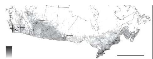


NO2 model (0-105 ug/m3) 0 1,000 km (1 km resolution)

Key Quotes:

“Fixed-site monitors may not capture entire populations, and measurements typically represent regional and between-city pollution differences due to monitor siting criteria, which prevent monitors from being placed in proximity to major roads and other pollution sources…Currently, the resolution of satellite data limits their use to representing regional pollution concentrations”

“The researchers assembled readily available data from the National Air Pollution Surveillance monitoring network in Canada and devised models to predict ambient concentrations of five pollutants at a national scale while capturing within-city pollution variability …Ground-level NO2 concentrations were estimated from tropospheric NO2 columns retrieved from the ozone monitoring instrument on the Aura satellite. Both PM2.5 and NO2 were estimated at a 0.1 × 0.1° resolution (~ 10 × 10 km)”

“To address the lack of local-scale geographic variability in the NAPS data, we incorporated deterministic gradients based on proximity to specific sources (i.e., vehicles and gas stations)”

“The NO2 model predicted 43% of the variability in readings predicted by LUR [Land Use Regression] models, compared with 18% using the common technique of simply interpolating between monitors using factors such as distance from the monitor, weather patterns, and known pollution sources”

“Predictions from the five models were influenced most strongly by satellite data for PM2.5 and NO2, vehicle emissions (represented by road type and location), industry emissions (from large point sources), and population density”

“The national pollutant models were applied to street block-face points, representing the locations of the Canadian population, to determine population exposure estimates. Estimates of average population exposure levels in Canada are PM2.5 8.39, NO2 23.37, benzene 1.04, ethylbenzene 0.63, and 1,3-butadiene 0.09 (µg/m3)”
Enhanced by Zemanta

Thursday, August 11, 2011

Managing Hot Spots in Urban Municipalities in England

Department for Environment, Food and Rural AffairsImage via WikipediaMapping Air Quality Action Plan Guidance available to Local Authorities (52 page pdf, prepared by Entec UK Limited for DEFRA, Apr. 14, 2011)

Also discussed here: Local Air Quality Management Webpage

Since legislation was enacted in 1995 to improve urban air quality in the UK, over 200 local authorities have declared over 500 Air Quality Management Areas (AQMA). The report reviewed today critically reviews the effectiveness of the guidance provided to the local authorities, identifies some shortcomings and makes recommendations. The lack of progress in reducing roadside emissions is notable.

Key Quotes:

“The Local Air Quality Management (LAQM) regime was thought to be effective at identifying areas where the Air Quality Objectives (AQOs) were likely to be exceeded”

“216 local authorities have declared 529 AQMAs. Some local authorities have declared the whole of their administrative areas as an AQMA, whereas others have declared AQMAs where “hot spots” of poor air quality occur within their area”

Road traffic emissions are the main contributor to current and forecast exceedences of the AQOs..Roadside concentrations of NO2 in particular have shown only a very small downward trend, and more recently there have been increases at some roadside locations in England.”

“[Some Identified Shortcomings And Comments] Diesel vehicles seem to have most effect on air quality in urban areas, but no measures to tackle this. Euro Emission Standards which should have resulted in improvements don’t seem to be materialising… Only really effective way of improving air quality is to reduce the number of vehicles on the roads. No clear measures about how to do this.. GIS Tool to highlight air quality hot spots and where there may be creeping air quality levels in areas in order to see visually where issues are located to try and address problems - Could be good tool for public to see issues also”

Some Recommendations:
  • “Local Authorities prefer to use best-practice examples when looking for ideas for measures to include within their Action Plans, especially where a measure has been effective elsewhere, in improving air quality. These examples will need to be easily accessible and updated regularly to show the use and effectiveness of new measures”
  • “Guidance for local authorities in order to raise awareness of air quality amongst members of the public and local councillors in relation to air quality and its synergies with planning, transport, climate change and its effects on health of local residents”
Enhanced by Zemanta

Wednesday, August 10, 2011

Car Dependency and Exclusion from Social Mobility

Social exclusion, DiscriminationImage via WikipediaTransport & Social Exclusion - A survey of the Group of Seven nations (44 page pdf, Summary Report, Editor: Dr Karen Lucas, Transport Studies Group, University of Westminster, the FIA Foundation, Feb. 2004)

Also discussed here: Social inclusion as a transport planning issue in Canada: Contribution to the FIA Foundation G7 Comparison (31 page pdf, Todd Litman, Victoria Transport Policy Institute, Apr.4, 2003)

And here: Transport and Social Exclusion - A United States View (29 page Word doc, L. Kennedy, Experts' Seminar, University of Westminster, the FIA Foundation, London, UK, Apr.4, 2003)

Today’s focus is on the many ways that the mobility needs of the poor and disadvantaged are met (or not) in G7 nations. The review article compares the extent of car dependency and the extent to which national transportation policies affect this mobility with large differences between North America on the one hand and Europe on the other. One factor is the degree of sprawl and large distances in Canada and the USA, as well as the greater access to alternative modes such as public transit in Europe and Japan. Value pricing (and congestion charging and road pricing) is being explored in the US (less so in Canada) to partly overcome this.


Key Quotes:

“About 20% of Canadian households do not own an automobile, about 10% are low-income, and about 10% of the population has a disability that constrains mobility”

“Automobile ownership is approaching saturation (a vehicle for each driver), particularly for non-poor households living outside of a few large cities (New York, Montreal, Toronto and Ottawa)”

“[in Canada] the average rural resident lives 10 kilometers from a physician, compared with 2 kilometers for urban residents, and that 7% of rural residents live 25 kilometers or more from a physician”

“Canada has no standard process for collecting national transport data, a consequence of the near-absence of a direct federal role in roadway planning and investment”

“Americans travel almost one hundred times more by automobile than by transit, yet the US spends less than four times as much on highways as transit. The US population grew 50 percent and US jobs doubled, and urban driving increased 420 percent since 1960. Yet, commuters riding transit to work decreased from 7.8 million to 6.1 million since 1960”

“Federal support was continued for pricing initiatives creating the Value-Pricing Pilot Program in the Transportation Equity Act for the 21st Century (TEA-21)…The projects involve HOV (High Occupancy Vehicle) lanes, toll roads, reversible HOV lanes, express passes, variable pricing and other alternatives”

“On the link between transport and social exclusion:

- access to a car.. seems to be essential to full participation in economic and social life in modern industrialised societies;

“On the public policy response in the Group of Seven:
  • the United Kingdom seems to be alone in attempting to make connections between poor transport amongst low income groups and other inequalities ..
  • in Canada, despite strong social programmes, there is little national effort to co-ordinate local transport planning or address transport related social exclusion problems;
  • Germany, Japan and Italy have developed specific policies to address mobility problems of disabled, older mobility impaired and isolated populations..”
Enhanced by Zemanta

Tuesday, August 9, 2011

Suburban Sprawl, Road Building and Vehicle Emissions

Major cities - per capita petrol use vs. popul...Image via WikipediaLock-in Effects of Road Expansion on CO2 Emissions: Results from a Core-Periphery Model of Beijing ( 39 page pdf, Alex Anas and Govinda R. Timilsina, Working Papers, State University of New York at Buffalo, Jun. 9, 2010)

By applying a traffic speed model to the megacity of Beijing, today’s review article examines the relationship between the addition of urban roads to traffic speed and emissions of CO2 and to what extent public transit plays an offset role for these emissions.


Key Quotes:

“Adding urban roads alleviates congestion, speeds up traffic and lowers CO2 in the intensive

margin (per car-km). But faster traffic attracts more car-trips in the extensive margin”

“The combined effect often increases aggregate emitted CO2. How much can improving public transit offset the higher emissions caused by new roads?”

“effective antidotes to substantial road expansion in the periphery of megacities:
  1. to make improvements in transit service in the periphery - drawing peripheral trips away from the car and onto transit.
  2. to reduce the core’s road capacity - increasing congestion per km in the core and thus inducing trips to switch to other modes, and to the less congested periphery”
“main drivers for the lock-in condition as it applies to developing megacities:
  1. Road capacity works powerfully in the extensive margin, overcoming the beneficial effects of the same capacity expansion in the intensive margin
  2. The relatively low market share of car trips and the large market share of the non-motorized modes that are observed in the megacities is part of the reason for the low cross-elasticity of car choice with respect to transit travel time relative to the own elasticity of car choice with respect to the travel time by car
  3. The presence of a large number of non-motorized travelers switching to bus dilutes the beneficial effects of car trips switching to transit
“Reducing roads in the core or making faster transit in the periphery draws population to the less congested periphery. While such a shift adds to urban sprawl, aggregate emissions are lowered and there is relatively less lock-in from adding peripheral road capacity”
Enhanced by Zemanta

Monday, August 8, 2011

Australian Tax and Environmental Price Reform

New ERP Gantry at Hill ViewTax Reform: Next Steps for Australia (42 page pdf, Commonwealth of Australia 2011)

Also discussed here: Australian Federal Government floats road pricing in new tax discussion paper (Road Pricing, Jul. 28, 2011)

Australia, Germany and the UK and a few other countries have governments whose policies are influenced by a party that promotes environmental and economic sustainabilility and keeps in power the party leading government, as long as its policies reflect the political reality. The minority Labour government in Australia is proposing a number of tax reforms including several that include environmental price reform in response to congestion, climate change and the graying population- as it affects traffic congestion, carbon fuel use and the need for equitable, used-based taxes. Portions of the Tax Reform Discussion Paper paper are quoted below.

Key Quotes:

“the costs of urban congestion are increasing, and are forecast to rise to $20 billion per annum by 2020”

“The Council of Australian Governments (COAG) Road Reform Plan is considering reforms to road charging and funding based on giving better incentives to operators by charging heavy vehicles on the basis of their mass, the roads they use, and the distance travelled”

“The AFTS review recommended that governments should consider the introduction of variable congestion pricing. Beyond that, the review commented that new technologies may further enable wider application of road pricing if proven cost-effective”

“The carbon price arrangements that the Government announced on 10 July 2011 are a cost effective way to achieve significant reductions in carbon pollution, by providing incentives to businesses to reduce their pollution and invest in clean energy. The two-stage plan for a carbon price mechanism will start with a fixed price period for three years, before transitioning to an emissions trading scheme

Some questions posed:
  • “Should Australia consider ways to more closely link road charging to the impact users have on the condition and upkeep of roads?
  • Is there a case to more closely link road charging to the impact users have on the level of congestion on particular roads?
  • Are there aspects of other tax arrangements that create unintended incentives for adverse environmental outcomes, or ways in which governments could use specific taxes to ensure that people take appropriate account of environmental impacts in their decision making?”
Enhanced by Zemanta