Friday, April 29, 2011

Adapting to Climate Change in Australia

Climate Change- Science and Solutions for Australia (168 page pdf, Editors: Helen Cleugh, Mark Stafford Smith, Michael Battaglia, and Paul Graham, CSIRO, April 2011)

Also discussed here: Australia’s Future Climate

The report reviewed today come from CSIRO, Australia’s lead agency for climate (and other areas of scientific research) which describes the adaptation needed for a range of climate impacts in this country which already has had to cope with major heat waves- many of which are similar, both in origin and response, to what is seen in North America and Europe. Highlighted below are examples of health impacts in particular.


Key Quotes:

Adaptation is about coping with the changes that are already happening or that appear unavoidable in the future”

“There is now wide scientific agreement that the world is heading for at least 2ºC warming, andpossibly 4ºC, by 20702 and that adaptation to the changed conditions that this implies has become a vital concern”

“Domains that are emerging as priorities are:
  • urban areas, including homes, offices, industries, transportation, water and energy systems, and overall design of towns and cities themselves
  • coastal zones and estuaries and all areas at risk of sea-level rise, storm surges, and floods
  • agriculture, the food supply, and other primary production, including mining
  • our natural environment, including forests, woodlands, grasslands, lakes, rivers, and deserts and all the plant and animal species within them.”
“In health, the most publicised impact is the increase in premature deaths that occurs during a severe hot spell. The numbers of these fatalities can be considerable: the southern Australian heatwave of 1938 is estimated to have claimed 438 lives, while that of January 2009 led to 374 deaths, even in the age of air-conditioning”

“Adaptation may include:
  • reshaping health-care services to developing early warning systems to reach all citizens (with a social network back-up for those most at risk)
  • preparation of the health system and hospital emergency departments, and improvements in maintenance programs for essential services
  • encouragement of behavioural changes by the public to reduce exposure to heat stress
  • retrofitting of old houses with better insulation
  • development of emergency response plans for heatwaves in all regions”
“Australia can expect an increase in disease due to the spread of insect vectors, with 0.6 to 1.4 million more people exposed to dengue fever by 2050, as well as a rise in waterborne and food-borne diseases”

“Higher temperatures are likely to cause an increase in the concentrations of volatile organic compounds and ozone in the atmosphere…increased ozone pollution is projected to cause a 40% increase in the projected number of hospital admissions by the period 2020–2030, relative to 1996–2005, and a 200% increase by the period 2050–2060)
Enhanced by Zemanta

Thursday, April 28, 2011

Proximity to Traffic Air Pollution and Birth Outcomes

Increased traffic exposure and negative birth outcomes: a prospective cohort in Australia (24 page pdf, Adrian G Barnett, Kathryn Plonka, W. Kim Seow, Lee-Ann Wilson and Craig Hansen, Environmental Health, Apr. 1, 2011)

Also discussed here: Early births linked to highway proximity (Sydney Morning Herald, Apr. 4, 2011)

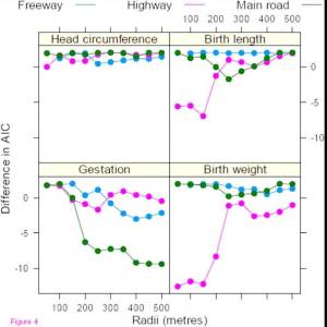
Today’s focus is on a paper that assessed the impact of the proximity of pregnant women to traffic with the birth weight of their children. The paper concluded a clear association up to 400 m from busy roads and speculated that one cause might be the impact of particulate matter on the growing fetus.


Key Quotes:

"The most striking result was the reduction in gestation time of 4.4 per cent - or almost two weeks - associated with an increase in freeways within 400 metres of the women's home"

“the negative effects of traffic on gestation were largely associated with main roads within 400 metres of the home, with much of the effect for roads within 200 metres”

“the public health implications are large because exposure to some level of air pollution is ubiquitous in urban areas, and pre-term and low weight babies: stay in hospital longer after birth, have an increased risk of death, and are more likely to develop disabilities”

"Pre-term and low-birth weight babies stay in hospital longer after birth, have an increased risk of death and are more likely to develop disabilities."

"We examined the distance between the home and busy roads to find the distance at which most of the negative effects on birth outcomes occurred because this has implications for local governments planning expansions or new roads,"

"Vehicles braking and starting means that road junctions have some of the highest levels of noise and air pollution"
Enhanced by Zemanta

Wednesday, April 27, 2011

How Should Cities Plan to Reduce Health Impacts from Climate Change?

Preparing a People: Climate Change and Public Health (6 page pdf, Catherine M. Cooney, Environ Health Perspect 119:a166-a171, Apr.1, 2011)

Today’s focus is on the need for cities to plan in advance for the health impacts from climate change that goes beyond the stress from heat waves which have been well documented in North America and Europe. Only few cities, such as Chicago, have prepared contingency plans to build in the resilience needed to adapt to the changing climate.


Key Quotes:

“Warmer year-round temperatures—milder winters, earlier spring thaws, and later frosts—have lengthened pollen seasons and brought forth a surge in toxic plants such as poison ivy changes in the composition and interaction of air pollutants such as ozone, particulate matter, and aeroallergens are expected to heighten human health effects of these pollutants”

“Public health organizations are not very well prepared, which is reflected in the numbers of injuries, illnesses, and deaths due to diseases sensitive to weather and climate..Climate change is one of the most serious public health threats facing our nation. ..Understanding the health impacts of climate change is one of the most vital pieces of information we need to make sound decisions about climate change adaptation,”

“ICLEI’s [Local Governments for Sustainability] Climate Resilient Communities Program..lays out five steps to get cities moving toward an adaptation plan: conduct a climate resiliency study, set preparedness goals, develop an actual climate preparedness plan, publish and implement the plan, and monitor and reevaluate resiliency”

“As a first step in developing a Monitoring, Early Warning, Data Integration, and Surveillance System, the working group is collecting information on the climate-related environmental and health surveillance data that are available at the federal level”

“By explaining that climate change is a human health threat—not just a threat to plants, penguins, and polar bears—public health professionals have a unique opportunity to enhance public engagement in the issue.”
Enhanced by Zemanta

Tuesday, April 26, 2011

Population Exposure Modelling in Canada

Creating National Air Pollution Models for Population Exposure Assessment in Canada (31 page pdf, Perry Hystad, Eleanor Setton, Alejandro Cervantes, Karla Poplawski, Steeve Deschenes, Michael Brauer, Aaron van Donkelaar, Lok Lamsal, Randall Martin, Michael Jerrett, and Paul Demers; Environ Health Perspect., Mar. 31, 2011)

Also discussed here: CAREX Canada (developing estimates of the number of Canadians exposed to known, probable and possible carcinogens in workplace and community environments)

The focus today is on a review of methods used in Canada to estimate exposure to air pollutants particularly in cities, based on observations from fixed ground station network (NAPS), space-borne satellite sensors and modelling tied together with statistical techniques such as kridging and land use modelling using GIS. The authors conclude that more can be deduced than from the conventional approach of interpolating between surface stations.


Key Quotes:

“Predicting air pollution concentrations at resolutions capable of capturing local-scale pollutant gradients over large geographical areas is becoming increasingly important for multi-city and national health studies, in population exposure assessment, and in support of policy, surveillance and regulatory initiatives”

“Fixed site monitors may not capture entire populations and measurements typically represent regional and between-city pollution differences due to monitor siting criteria, which prevent monitors from being placed in close proximity to major roads and other pollution sources”

“This research is part of Carex Canada, a national surveillance initiative estimating the number of Canadians potentially exposed to known or suspected environmental and occupational carcinogens”

“only 35 NAPS [National Air Pollution Surveillance] monitors were located within 500 meters of a major road and only seven monitors were within 500 meters of a major industrial emission source”

“Estimates of average population exposure levels in Canada are PM2.5 8.39, NO2 23.37, benzene 1.04, ethylbenzene 0.63 and 1,3-butadiene 0.09 (μg/m3)“

“Applying national models to routinely collected population location data can extend land use modeling techniques to population exposure assessment and to informing surveillance, policy and regulation”
Enhanced by Zemanta

Thursday, April 21, 2011

The EU White Paper for Transportation to 2050

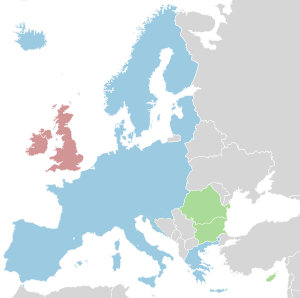
Schengen AgreementImage via WikipediaWHITE PAPER - Roadmap to a Single European Transport Area – Towards a competitive and resource efficient transport system (31 page pdf, European Commission, Mar. 28, 2011)

Also discussed here: EU transport chief releases radical plan to cull petrolheads (Carlton Reid, BikeBiz, Mar. 29, 2011)

And here: EU to ban cars from cities by 2050 (The Telegraph, Mar. 30, 2011)

The focus today is on the recently released White Paper from the EU which outlines various steps to move toward a carbon free major cities within the next 20 years through the use of new technology, investments in infrastructure and relying on user/polluter pays to achieve greater mobility.

[youtube=http://www.youtube.com/watch?v=qHx5SL0ZrpU]

Transport White Paper presented in Brussels

(2.15 min You Tube video)

Key Quotes:

“The plan also envisages an end to cheap holiday flights from Britain to southern Europe with a target that over 50 per cent of all journeys above 186 miles should be by rail”

“"That means no more conventionally fuelled cars in our city centres..Action will follow, legislation, real action to change behaviour"

“people contaminating city centres with exhaust fumes and engine noise will get the same respect as dog owners not collecting their pets droppings or men urinating in public”

"Curbing mobility is not an option, neither is business as usual. We can break the transport system's dependence on oil without sacrificing its efficiency and compromising mobility. It can be win-win"

“Future development must rely on a number of strands:
  • Improving the energy efficiency performance of vehicles across all modes. Developing and deploying sustainable fuels and propulsion systems;
  • Optimising the performance of multimodal logistic chains, including by making greater use of inherently more resource-efficient modes, where other technological innovations may be insufficient (e.g. long distance freight);
  • Using transport and infrastructure more efficiently through use of improved traffic management and information systems”
3 of the 10 Goals:
  • Halve the use of ‘conventionally-fuelled’ cars in urban transport by 2030; phase them out in cities by 2050; achieve essentially CO2-free city logistics in major urban centres by 2030
  • 30% of road freight over 300 km should shift to other modes such as rail or waterborne transport by 2030, and more than 50% by 2050, facilitated by efficient and green freight corridors.
  • Move towards full application of “user pays” and “polluter pays” principles and private sector engagement to eliminate distortions, including harmful subsidies, generate revenues and ensure financing for future transport investments.
Enhanced by Zemanta

Wednesday, April 20, 2011

Roadside Traffic Emissions and Lung Transplants

Driving Cars in a Traffic JamThe impact of traffic air pollution on bronchiolitis obliterans syndrome and mortality after lung transplantation (Abstract, Tim S Nawrot, Robin Vos, Lotte Jacobs, Stijn E Verleden, Shana Wauters, Veerle Mertens, Christophe Dooms, Peter H Hoet, Dirk E Van Raemdonck, Christel Faes, Lieven J Dupont, Benoit Nemery, Geert M Verleden, Bart M Vanaudenaerde, Thorax, British Medical Association, Mar. 23, 2011)

Also discussed here: Road Traffic Pollution Doubles Risk of Rejection After Lung Transplant (Science Daily, Mar. 24, 2011)

Today’s review summarizes research into the impact of roadside emissions on those who have undergone lung transplants. Although this is a small segment of the population, the sensitivity of health damage from living near heavy traffic is clear.

Key Quotes:

“Approximately half of all patients who underwent a lung transplantation suffer from bronchiolitis obliterans syndrome (BOS), the clinical correlate of chronic rejection, within 5 years after transplantation”

“Those who lived within a 171 metre radius of a main road were twice as likely to develop the syndrome and more than twice as likely to die as their peers who lived further away from this source of pollution.”

“for every 10-fold increase in distance from a main road, patients were 43% less likely to develop the syndrome and 28% less likely to die”

"These population attributable fractions are significant not only in terms of patient suffering but also in terms of healthcare costs,"

"Traffic related air pollution appears to constitute a serious risk ... If confirmed by other studies, [it] has substantial clinical and public health implications."
Enhanced by Zemanta

Tuesday, April 19, 2011

Modelling Exposure to Health Risks from Air Pollution

Combining Regional- and Local-Scale Air Quality Models with Exposure Models for Use in Environmental Health Studies (12 page pdf, Vlad Isakov, Jawad S. Touma, and Janet Burke, Danelle T. Lobdell, Ted Palma, Arlene Rosenbaum, Haluk Ozkaynak, Journal of the Air & Waste Management Association, Vol. 59:461– 472, Apr. 2009)

Also discussed here: Community-Focused Exposure and Risk Screening Tool (C-FERST) (EPA, Human Exposure and Atmospheric Science)

And here: The EPA's human exposure research program for assessing cumulative risk in communities (Valerie G Zartarian and Bradley D Schultz, Journal of Exposure Science and Environmental Epidemiology (2010) 20, 351–358; Apr.15, 2009)

And here: EPA’s Community-Focused Exposure and Risk Screening Tool: C-FERST and its potential use for EJ efforts(63 slide pdf, Valerie G. Zartarian, B. Schultz, M. Smuts, T. Barzyk, D. Hammond, M. Medina-Vera, A. Geller, Strengthening Environmental Justice Research and Decision Making Symposium, Mar. 18, 2010)

Today’s focus is on ways of measuring the exposure of humans to air pollution and the models being used to assess the health risks, including the EPA’s Community-Focused Exposure and Risk Screening Tool (C-FERST), the Hazardous Air Pollutant Exposure Model [HAPEM] and the Stochastic Human Exposure and Dose Simulation [SHEDS] model. The noted links point to reports that describe how each functions. One conclusion is that the complex patterns and gradients in air pollution across a city requires more than one or two representative measurement points if one needs to adequately define the health risk to urban communities.


Key Quotes:

“Communities want to understand their environmental issues in the context of risk.. rely on risk perception if difficulties accessing, interpreting data”

“The Community-Focused Exposure and Risk Screening Tool (C-FERST).. is a “one-stop shop” GIS and resource access Web tool for conducting community assessments”

“Future versions of C-FERST ..: ongoing human exposure science; collaboration/integration with ecological research; integration with other tools; more fully populated exposure/risk maps and environmental issue profiles; building capacity for more complete cumulative assessment and risk ranking; incorporation of EPA cumulative risk guidance and non-chemical stressors research; "what-if" scenarios for assessing impacts of community actions; incorporation of more sustainability aspects”

“Understanding relationships between sources of air pollution, ambient air concentrations, and exposures is fundamental to developing effective air pollution standards and regulations.”

“Population-based human exposure models predict the distribution of personal exposures to pollutants of outdoor origin using a variety of inputs, including air pollution concentrations; human activity patterns, such as the amount of time spent outdoors versus indoors, commuting, walking, and indoors at home; microenvironmental infiltration rates; and pollutant removal rates in indoor environments”

“The results indicate that there is a strong spatial gradient in the predicted mean exposure concentrations near roadways and industrial facilities that can vary by almost a factor of 2 across the urban area studied”

“our results indicate 20–30% differences due to commuting patterns and almost a factor of 2 difference because of near-roadway effects”

“these studies assume that a single monitor, or an average of only a few monitors, is representative of complex patterns of exposures within a large urban area”

“exposure models are designed to utilize modeled air concentrations, combined with human activity data and indoor/outdoor relationships for pollutants, to estimate distributions of exposures for populations of interest”
Enhanced by Zemanta

Monday, April 18, 2011

An Urban Air Pollution Simulator

Smog City
Today’s review is about a computer simulator from California showing ozone levels over a day as a function of population, temperature, amount of cars and trucks, industry etc.


Key Quotes:

“an interactive air pollution simulator that shows how your choices, environmental factors, and land use contribute to air pollution”

“Ozone levels depicted in Smog City are estimated by simulating the air quality over Sacramento, California using a computerized model of the region”

“As each hour of the day passes, emissions from human activities, such as industry, cars, and trucks, and from natural sources like trees and plants, are injected into Smog City's atmosphere.”

“Because Smog City's relationships are based on a simplified model of complex atmospheric processes in Sacramento, California, there is no guarantee that they are scientifically accurate for this or other regions.”

Enhanced by Zemanta

Friday, April 15, 2011

Abogo and the Cost of Commuting from the Suburbs

ABOGO (Abogo is a tool that lets you discover how transportation impacts the affordability and sustainability of where you live)

Also discussed here: Abogo Cities: Helping You Live a Low Transportation Cost Life

And here: “Cheap” Seattle Suburbs Aren’t Cheap if You Drive (Erica C. Barnett, Publicola, Mar. 24, 2011)

Today’s post highlights an internet service to estimate the cost of living in or around and far from the centre of cities, based on the cost of transportation- expressed both in terms of dollar costs/month and greenhouse gas emissions. The sample shown below compares the costs for a location in Manhattan, New York City which is $336 and ¼ ton per month (similar costs for areas shown in green) with the longer commutes to the west and east (where red represents over $1000/month). Different estimates (with higher resolution) may be made for other American cities. It clearly shows the savings possible from urban living.


Key Quotes:

“Abogo measures the money an average household from your region living in your neighborhood would spend getting around, including car ownership, car use, and transit use. It also tells you what the CO2 generated by this car use would be. With this information, you can measure the true cost and impact of where you live”

“the typical definition of “affordable” housing—which tends to be in far-flung suburbs that require long drives along sprawling freeways to get to work—includes only the cost of a rent or mortgage and ignores the cost of transportation—which, in the suburbs, can amount to more than half of household income”

“living further from the city because it’s “cheaper” is a false choice”
Enhanced by Zemanta

Thursday, April 14, 2011

Measuring Ultrafine Particle Emissions

Diesel smoke from a big truck.Image via WikipediaChallenges and Approaches for Developing Ultrafine Particle Emission Inventories for Motor Vehicle and Bus Fleets (21 page pdf, Diane U. Keogh and Darrell Sonntag, Atmosphere 2011, 2(2), 36-56, Mar. 24, 2011)

The research reviewed today looks at the factors that need to be considered when developing a system to collect and archive ultrafine particle data, taking into account both the characteristics of their emission and the potential health risks they pose for human health. Only one such inventory exists in the world - in Brisbane, Australia. As no air quality regulations exist for these particles and many cities depend on diesel buses for public transit, the requirement seems clear in order to begin to define and address this health threat.

Key Quotes:

“UFPs are not currently regulated by ambient air quality standards”

“The particle number emission rates for heavy-duty diesel vehicles are one to two orders of magnitude higher than gasoline-fueled passenger cars. In urban areas heavy duty diesel vehicles, including buses, are major sources of exposure for UFP

“Colder temperatures significantly increase the concentration of UFP in motor vehicle exhaust measured from the roadside [58], on-road and on-board vehicle dilution tunnels”

“Concentrations of UFPs generated by motor vehicle fleets tend to be higher within 100 metres of the emission source under typical meteorological conditions. Studies have shown that particle concentration decreases with distance from the road up to around 300 metres”

“although heavy duty vehicles contributed only 6% of total vehicle kilometers traveled in the study region, this vehicle class contributed more than half the region’s particle number (ultrafine particle) and PM1 emissions due to their high emission rates”

“particle number emission rates (particle number/second) were highest for the buses on high-speed freeway driving conditions. When the bus route was divided into 50-meter segments, the segments in which the bus emitted the most particles occurred near bus stops and intersections where the bus was accelerating from stop”

“bus idling time needs to be considered as emission hot spots can occur where heavy-duty diesel vehicles idle for extended periods ..and how close the path chosen by (or available to) pedestrians is to the traffic source or to accelerating buses and acceleration distances”
Enhanced by Zemanta

Wednesday, April 13, 2011

The Impact of Cities on the Environment

The environmental impact of cities (22 page pdf, Peter Newman, Environment and Urbanization, Oct. 2006)

Today’s review is of a paper by Prof Newman, recently the environment commissioner for Sydney, Australia. The paper compares three methods of estimating urban impacts: population impact method, ecological footprint and sustainability assessment, concluding that the latter offers the most in terms of positive policy objectives.


Key Quotes:

“Although the population impact model provides some perspective on local impact, and the Ecological Footprint model on global impact, only the sustainability assessment approach allows us to see the positive benefits of urban growth and provides policy options that can help cities reduce their local and global impact while improving their liveability and opportunity, which continue to drive their growth”

Population Impact Approach

“there are many aspects of cities that are not explained by this simple biological model. It does not explain why people are attracted to cities, or how economies of scale and density can actually lead to better urban services that manage natural resources and wastes or public transport”

“The top four “alpha” cities of the global economy – London, Paris, Tokyo and New York – still appeal to their residents and visitors despite being large and dense”

“The idea of spreading the population of such cities into small systems of intensive rural production has been suggested by some, although the arithmetic shows that a complete destruction of the most productive agricultural land would soon occur”

Ecological Footprint

“The calculation is largely artificial in that it relates energy consumption to the amount of land that would be needed to grow the equivalent in fuel crops”

“It is still mostly a negative measure of the impact of cities rather than a more positive measure of what cities should do”

Sustainability Assessment

“The objective of sustainability assessment is to achieve a simultaneous consideration of social, economic and environmental issues and to achieve a “net benefit” outcome in each area, with minimal trade-offs”

“defined sustainability as . . reducing Ecological Footprint (energy, water, land materials, waste) while simultaneously improving quality of life (health, housing, employment, community . . .) within the capacity constraints of the city.”

“Sustainability assessment approaches the future by asking of any development that it produce “net benefit” in all three areas of environment, social and economic performance. This means that there should not be a trade-off between the three areas, as has so often been the case”
Enhanced by Zemanta

Tuesday, April 12, 2011

Hockey, Indoor Rinks and Health Risks

Hidden Dangers at Indoor Ice Rinks (NBC 7 minute video)

Also discussed here: Many Other Forms of Air Pollution (Effects of Air Pollution on Our Health, Feb. 10, 2011)

And here: Indoor Air Quality and Ice Arenas (EPA)

And here: Air Quality in Ice Rinks (DP Hockey, CBC News)

Today’s review post comes thanks to the blog on “Effects of Air Pollution on Health” which highlighted the health risks faced by skaters in indoor rinks from fuel-powered resurfacing machines- known in Canada as Zambonis- which emit CO2 and PM (as opposed to electric powered). The video is startling in showing how long dangerously high pollution levels persist in unventilated rinks.


Key Quotes:

“Indoor pollution sources that release gases or particles into the air are the primary cause of indoor air quality problems. Inadequate ventilation can increase indoor pollutant levels by not bringing in enough outdoor air to dilute emissions from indoor sources and by not carrying indoor air pollutants out of the building”

“In enclosed ice arenas, a primary source of indoor air concerns is the release of combustion pollutants such as carbon monoxide (CO), nitrogen dioxide (NO2), and particulate matter (PM) into the indoor air from the exhaust of fuel-fired ice resurfacers

“the CBC tested 42 arenas in Halifax, Sudbury, Winnipeg, Edmonton and Vancouver. Of those rinks, 24 per cent tested higher than 60,000 particles of pollution per cubic centimetre — a level that Rundell said decreases lung capacity.. 14 per cent also tested higher than 100,000 particles of pollution per cubic centimetre, roughly the equivalent of the air quality that might be experienced standing next to Toronto's Highway 401, the busiest road in the country”

“Improving ventilation systems in buildings or installing vents nearer to the ice rather than in the roof could help clear the air indoors. Another, more costly solution is to start using ice resurfacing machines powered by electricity to eliminate the use of fossil fuels”

“[in the US] there are no laws requiring carbon monoxide detectors in rinks, so kids can be inhaling these fumes and not even know about it”
Enhanced by Zemanta

Monday, April 11, 2011

Some Truths about Congestion and the Case for Congestion Pricing

Congestion is Welfare Reducing (Andrew Smith, Seattle Transit Blog, Feb. 22, 2011)

The article reviewed today in simple terms makes the case for road tolls as likely the only sustainable way to reduce congestion – which in the U.S. cost 4.8 billion hours in time wasted in the year 2010. It all comes down to more efficient use of roads and the traffic that uses them.


Key Quotes:

“Too many drivers trying to access a roadway at the same time – in economic speak, excess demand for a good in fixed supply – causes congestion”

“When there’s no traffic, adding new drivers to a roadway does not reduce travel times.. once a highway becomes congested, adding more cars to the road does not increase the number of cars the road carries”

“The demand for highway transportation represents the value that consumers place on traveling at a particular time, in particular manner and to their particular places”

“The lower the cost of driving, the more people drive. This means drivers taking longer trips or more trips as costs decrease.”

“When roads are free, the only cost to drive is time. Once a roadway approaches congestion, each additional driver impacts all other drivers, slowing them down and costing them time”

Congestion pricing solves this problem. You put tolls in place and time is exchanged for money. People who value their trip less than the toll price won’t make the trip”

“Congestion pricing would also be good for transit. Bus service is priced in hours, not distance, so reducing the amount of time buses spend in traffic would reduce the cost of operating the same level of service”
Enhanced by Zemanta

Friday, April 8, 2011

Resilience, Intensification and Sustainable Cities

Traffic congestion of automobiles caused of pe...Image via WikipediaCities in search of resilience (Phil McDermott, Cities Matter, Feb. 3, 2011)

Also discussed here: What kind of Cities do we Want, Sustainable, Liveable or Resilient? (Owen McShane, newgeography, Mar. 12, 2011)

Today’s review comes from Auckland, New Zealand, just after its major earthquake and the earthquake and tsunami which affected much of northern Japan. Both events had major destructive impacts on cities in these countries despite advanced disaster preparativeness. One thinks of New Orleans after Hurricane Katrina or the prospects for earthquake-prone Vancouver, at the top of most lists of sustainable cities. Or, how often high population densities in urban cores are associated with high and increasing levels of traffic congestion and pollution. Despite the many economic and environmental benefits, there are several cautions that need to be considered when urban planners try to make their cities more compact, especially as climate change raises the risk and intensity of more natural disasters in the future.

Key Quotes:

“Natural disturbances, whether geophysical (tsunami, earthquakes, mudslides) or climatic (flooding, hurricane strength winds, tidal surges), become disasters if they strike heavily populated centres”

Reasons to question urban compactness:
  • “It relies on sophisticated, centralised interdependent systems of services..greater capacity for disruption when any one part fails.
  • Poorly designed intensification reduces permeable surfaces, intensifying flood impacts.
  • Converting brownfield and even greenfield sites to housing or mixed use reduces the safety valve of open space
  • Crowding more people into smaller spaces around constrained road capacity reduces prospects for rapid evacuation
  • Lifting the density of buildings increases the consequential impacts of severe events by such things as the collapse of structures, the spread of fire, and the transmission of disease.
  • Mixing uses increases the risk of injury and destruction when people live close to premises where hazardous and flammable goods may be stored.
  • Reducing the space available reduces the capacity of people to fend for themselves, particularly if the consequences of a disruptive event are prolonged”
“smaller centres, within, on, or beyond the edges of large cities, with a full range of services and amenities and a high level of self sufficiency are likely to offer more resilience to communities than centralised, hierarchical and interdependent services stretched over the entire city”

“Traditional suburbs, perhaps scaled down, will have their place, providing private and public spaces to nurture families and nature. High density suburbs with extensive parks, green belts, and generous transport corridors are another option”

“the risk of disasters in our cities being compounded by crowding and mean design calls for putting resilience into the urban design equation”
Enhanced by Zemanta

Thursday, April 7, 2011

Are Roads a Public Good?

Urban[ism] Legend: Transportation is a Public Good (Market Urbanism, Feb. 22, 2011)

Also discussed here: Are Roads Public Goods, Club Goods, Private Goods, or Common Pools? (53 page pdf, Bruce Benson, Florida State University)

Today’s review article looks at the concept of a public good as applied to roads (and by extension to road tolls) and to transit, showing that is how the good is used or overused that something becomes public or private.


Key Quotes:

“Public goods have two distinct aspects: nonexcludability and nonrivalrous consumption. “Nonexcludability” means that the cost of keeping nonpayers from enjoying the benefits of the good or service is prohibitive. And nonrivalrous consumption means that one consumer’s use does not inhibit the consumption by others. A clear example being that when I look at a star, it doesn’t prevent others from seeing the same star”

“If a road is not congested, then one person’s use does not effect anyone else. In this case, use is not rival in consumption, and the road is a public good. Yet if a road is congested, then use of that road yields a negative externality. When one person drives on the road, it becomes more crowded, and other people must drive more slowly. In this case, the road is a common resource”

“a congested (or tolled to prevent congestion) road is a private good, and in the case that a roadway is oversupplied, it is simply a “low-congestion good”, often called a “club good.”

“the fact roads are either private goods or grossly oversupplied help weaken anyone’s case that transportation is government’s business in the first place”
Enhanced by Zemanta

Wednesday, April 6, 2011

Impact of London Congestion Charge Scheme on Air Pollution

The impact of the congestion charging scheme on ambient air pollution concentrations in London (21 page pdf, R.W. Atkinson, B. Barratt, B. Armstrong, H.R. Anderson, S.D. Beevers, I.S. Mudway, D. Green, R.G. Derwent, P. Wilkinson, C. Tonne, F.J. Kelly, Atmospheric Environment, Volume 43, Issue 34, Pages 5493-5500, Nov, 2009)

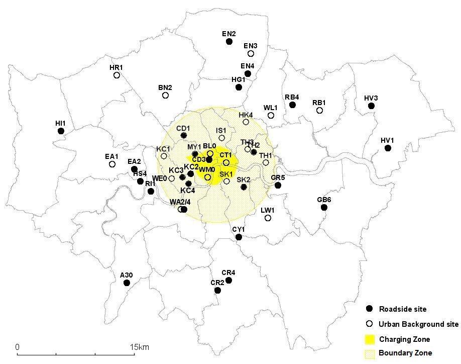
Today’s reviewed report is a land mark report on London’s congestion charging system, introduced in 2003. The authors found significant reductions in pollutants in the charging and boundary zone as a function of distance from the centre, using both roadside and ambient monitors, reflecting the 18% reduction in traffic. Finding the precise impact of the charging system was made more difficult because of changes in the ambient air quality across the entire city and other measures that extended beyond the relatively small (22 km2) charging zone, factors that future congestion charging schemes would need to take into account.


Percentage change in geometric mean pollutant concentrations at background monitoring stations stratified by station location (within zone, boundary and control zones) and distance from CCZ centre

0 indicate stations within CCZ,

1 with cross indicate stations surrounding the zone boundary( indicate stations in control zone (8 km+ from zone centre).

The Y axis shows percent change pre-post CCS implementation and the X-axis shows the distance in km from the centre of the charging zone

Key Quotes:

“On 17th February 2003, a congestion charging scheme (CCS), operating Monday–Friday, 07:00–18:00”

“The main objective of the CCS was met: in the first year traffic volumes entering the zone fell by 18% and congestion (defined by the time taken to travel 1 km) in the zone was reduced by 30% compared to pre-charging levels”

“this is the first evaluation of the effects of a permanent traffic management scheme on pollution levels in a major city. With road pricing schemes being considered in the UK and elsewhere in the world this study provides valuable information to policy makers and the general public”

“The question of whether the observed reduction in background concentrations of NO, PM10 and CO and the increases in background NO2 and O3 observed within the zone are attributable to the implementation of the CCS is problematic. The congestion charging scheme was one specific action within a general programme of measures to reduce traffic congestion and air pollution across London as a whole”

“because of the concentration of traffic in the centre, these other measures may have had a greater relative impact in central London than outer London, thus explaining the observed temporal patterns in pollution observed in this analysis”

“our study suggests that the introduction of the CCS in 2003 was associated with small temporal changes in air pollution concentrations in central London relative to outer areas”
Enhanced by Zemanta

Tuesday, April 5, 2011

Neural Network Modelling and Residential Building Energy Consumption

Analysis of a Residential Building Energy Consumption Demand Model (13 page pdf, Wei Yu, Baizhan Li, Yarong Lei and Meng Liu, Energies 2011, 4(3), 475-487, Mar. 10, 2011)

One of the largest sources of greenhouse gas emissions world-wide is the fuel used to heat (or cool) residences. Today’s review article uses advanced neural network modelling to analyse energy consumption for a large (32M population) city in southwestern China (Chongqing), using a set of 16 filtered indicators. Comparison of model results with actual ones showed less than 3% error and promise for further applications to optimize building energy consumption.


Key Quotes:

“Building energy consumption accounts for one-third of the societal energy consumption in China, and has the largest energy-saving potential”

“develops a residential building energy consumption demand model based on a back propagation (BP) neural network model”

“16 indicators of energy consumption in Chongqing residential buildings are introduced by analyzing the characteristics of Chongqing residential buildings, and then the index system of the BP neural network prediction model is established”

“There are three categories of factors effecting living energy consumption: internal factors, social factors and individual factors.. The internal factors are the main factors..which affect the living energy consumption changes…. individual factors have a great randomness and not suitable for quantitative methods…Social factors can be affected by “the five-year plan” primarily on the basis of relevant policies and regulations, so that the forecast model can be corrected, so social factors are also not considered“

“the energy value difference between the one predicted by the established BP artificial neural network model of residential building energy requirements and the actual one is quite small, with an error of 3% or less”

“The model can provide the guidelines for Chongqing residential building energy-saving programs and measures by predicting the energy consumption of residential buildings in Chongqing”
Enhanced by Zemanta

Monday, April 4, 2011

Is there (or should there be) a War on Cars?

The First Casualty of a Non-Existent War: Evaluating Claims of Unjustified Restrictions on Automobile Use, and a Critique of 'Washingtons War On Cars and the Suburbs' (35 page pdf, Todd Litman, Victoria Transport Policy Institute, Mar. 11, 2011)

Also discussed here: Washington’s War on Cars and the Suburbs: Secretary LaHoods False Claims on Roads and Transit (24 page pdf, Wendell Cox, Heritage Foundation, Jun. 17 2010)

Todd Litman’s latest report is the focus of today’s post. He analyzes the claims by a critic of sustainable transportation, Wendell Cox, point by point, with references to established authoritative sources, concluding that there is no war. Much would be improved through acknowledgement and accommodation of the needs of the motorist with those who choose other transportation options, be it transit, cycling or walking.


Key Quotes:

“"The first casualty when war comes is truth."

“Evidence of a war consists of exaggerated objections to policies such as traffic calming (which increases traffic safety), busways and bike lanes (justified to improve transport options, which helps reduce traffic and parking congestion), and more efficient road and parking pricing (justified to reduce traffic and parking problems, and finance facilities)”

“These are no more anti-car than a healthy diet is anti-food”

Incorrect assertions:
  • “Critics are wrong to assume that “coercing people out of their cars” is a threat to motorists. It is simply a blunt description of transportation demand management
  • Critics are wrong in assuming that such policies necessarily harm motorist
  • Critics underestimate demand for alternative modes
  • Critics exaggerate the threat that bike and bus lanes represent to motorists
  • Critics are wrong to claim that raising road tolls, parking fees or fuel taxes is unfair
  • Critics are wrong to claim that alternative modes receive an excessive share of funding
  • Critics apply a double standard when they criticize highway account expenditures on alternative modes
  • Critics are wrong to claim that transportation demand management programs are ineffective”
“TOD [Transit-Oriented Development] residents typically own 10- 30% fewer vehicles and drive 20-60% fewer miles than in conventional, automobile-dependent communities”

“My research indicates that residents of urban regions with high quality rail transit drive about 20% fewer annual miles than residents of regions that lack such rail, and residents of transit-oriented neighborhoods typically drive 40-60% less than residents of automobile-dependent areas, resulting in larger energy savings”

“Although few motorists want to stop driving altogether, many would prefer to drive less and rely more on walking, cycling and public transport, provided those alternatives are convenient, comfortable, safe and affordable”
Enhanced by Zemanta