Also discussed here: A Pollution Model Upgrade? Incorporating the Local Scale in National Models (1 page pdf, Environmental Health Perspectives, volume 119, number 8, Aug. 2, 2011)
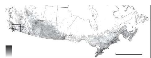
Today’s focus is on a study of how well the national air pollution network, supplemented by satellite data and regional land use regression modeling, can estimate local variability in 7 Canadian cities. Modelling improved the prediction of variability of NO2 from 18% using standard interpolation to 43% with supplemental data and techniques.

NO2 model (0-105 ug/m3) 0 1,000 km (1 km resolution)
Key Quotes:
“Fixed-site monitors may not capture entire populations, and measurements typically represent regional and between-city pollution differences due to monitor siting criteria, which prevent monitors from being placed in proximity to major roads and other pollution sources…Currently, the resolution of satellite data limits their use to representing regional pollution concentrations”
“The researchers assembled readily available data from the National Air Pollution Surveillance monitoring network in Canada and devised models to predict ambient concentrations of five pollutants at a national scale while capturing within-city pollution variability …Ground-level NO2 concentrations were estimated from tropospheric NO2 columns retrieved from the ozone monitoring instrument on the Aura satellite. Both PM2.5 and NO2 were estimated at a 0.1 × 0.1° resolution (~ 10 × 10 km)”
“To address the lack of local-scale geographic variability in the NAPS data, we incorporated deterministic gradients based on proximity to specific sources (i.e., vehicles and gas stations)”
“The NO2 model predicted 43% of the variability in readings predicted by LUR [Land Use Regression] models, compared with 18% using the common technique of simply interpolating between monitors using factors such as distance from the monitor, weather patterns, and known pollution sources”
“Predictions from the five models were influenced most strongly by satellite data for PM2.5 and NO2, vehicle emissions (represented by road type and location), industry emissions (from large point sources), and population density”
“The national pollutant models were applied to street block-face points, representing the locations of the Canadian population, to determine population exposure estimates. Estimates of average population exposure levels in Canada are PM2.5 8.39, NO2 23.37, benzene 1.04, ethylbenzene 0.63, and 1,3-butadiene 0.09 (µg/m3)”
Related articles
- Traffic Air Pollution and Health Impacts in Urban Italy (pollutionfree.wordpress.com)
- Ambient Air Pollution in Canada and Environmental Pricing (pollutionfree.wordpress.com)
- Increased Cancer Risk in These Polluted Cities (fitsugar.com)
- Does Traffic Air Pollution Cause Cervical and Brain Cancer? (pollutionfree.wordpress.com)
- Comparing the Health Risks of Smoking and Air Pollution (pollutionfree.wordpress.com)
- Communities At Risk from Gas Industry Air Pollution - Interview with NRDC's Amy Mall (desmogblog.com)
- How smog affects the human body (kevinmd.com)
- Health Costs of Air Pollution from Traffic in U.S. Cities (pollutionfree.wordpress.com)
- LA Ranks Number One For Dirty Air (fitsugar.com)
- U.S. Had 2,000 Unhealthy Air Alerts in 2011 So Far (treehugger.com)
- Classifying Assessing Health Impacts from Urban Air Pollution Differences (pollutionfree.wordpress.com)
- Biking on busy streets linked to heart risks (sfgate.com)

No comments:
Post a Comment